About enviroGRIDS
List of acronyms | |  | | 
There are many abbreviations and acronyms used in the enviroGRIDS project. To facilitate the reading of this website and the various products, we provide below a list of used acronyms. This list is updated as new acronyms emerge. API Application Programming Interface |
Gender Action Plan | |
FP7 projects must have a Gender Action Plan (GAP), reflecting the European Commission’s desire to promote gender equality as a mainstream issue. The enviroGRIDS Gender Committee aims at ensuring gender equitability, defining specific women needs and proposing appropriate solutions (mobility, meetings) and actions to the Coordination and Management team and the Project Management Board. It is composed of three members elected amongst partners. Gender Committee members (Apr. 2011 - Mar. 2013): Ines Grigorescu (IGAR) Past Gender Committee members (Apr. 2009 - Mar. 2011): Tamar Bakuradze (GeoGraphic) The reports on Gender issues in enviroGRIDS can be find below if you are logged in. Links to resources for women in science can be found on the website of our partner project ACQWA. The Black Sea Catchment | |
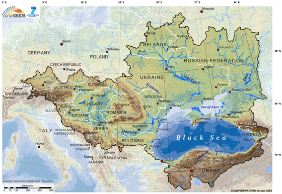
The core environmental problem of the Danube River Catchment can be described as “ecologically unsustainable development and inadequate water resources management” (PCU 1999). The problems are caused by different factors, such as: inadequate management of wastewater/solid waste, ecological unsustainable industrial activities, and inadequate land management and improper agricultural practices. They generate several direct consequences: pollution of surface/groundwater, eutrophication, and accelerated runoff /erosion. These consequences have, on the other hand, the following main effects: decline in quality of life, human health risks, degradation of biodiversity, economic decline, and reduced availability of water. The Black Sea itself is also affected by severe environmental degradation. In 1995, it was rated with the highest concerns in five out of seven environmental categories, making it the worst of any of the European seas (Stanners and Boudreau 1995). Some signs of recovery have been observed in the last years, but eutrophication remains a severe problem. The Black Sea Hydrological Catchment (see Figure below) represents a very interesting case study to test the capacity of integrating large data sets to assess vulnerability and sustainability issues related to freshwater resources as various scales. The project is therefore essentially concentrating on the terrestrial part of the Black Sea Hydrological Catchment, not to be confused with the marine part often considered when using the Black Sea Basin terminology.
References PCU (1999). Strategic Action Plan for the Danube River Basin 1995-2005 – Revision 1999. Danube Pollution Reduction Programme, Programme Co-ordination Unit Stanners, D. and Bourdeau, P. (Eds.) (1995), “Europe’s Environment: The Dobris Assessment,” European Environment Agency Task Force, European Environment Agency, Copenhagen, Denmark EnviroGRIDS building blocks | |
EnviroGRIDS @ Black Sea Catchment aims at building capacities in the Black Sea region to use new international standards to gather, store, distribute, analyze, visualize and disseminate crucial information on past, present and future states of this region, in order to assess its sustainability and vulnerability. To achieve its objectives, EnviroGRIDS will build an ultra-modern Grid enabled Spatial Data Infrastructure (GSDI) that will become one component in the Global Earth Observation System of Systems (GEOSS), compatible with the new EU directive on Infrastructure for Spatial Information in the European Union (INSPIRE). EnviroGRIDS is indeed officially registered as a specific task in the GEO work plan 2009-2011. Gap analyis First, a gap analysis will allow identifying areas where most efforts are needed to reinforce existing observation systems in this region. Then, spatially explicit scenarios of key drivers of changes such as climate, demography and land cover will be created. These scenarios will feed into hydrological models calibrated and validated for the entire Black Sea Catchment. EnviroGRIDS will rely on the largest GRID computing infrastructure in the world (EGEE) that will transform elements of software underpinning scenarios and models onto a grid enabled system. The combined impacts of expected climatic, demographic, land cover and hydrological changes will be measured against GEO Societal Benefit Areas. Specific outcomes will be analyzed and made accessible to both the expert and non-expert public through a state-of-the-art web interface providing advance warning to target audiences about risks. The know-how and results of the project will be made available to countries within the Black Sea Catchment, and to the rest of the world, by providing a free and open source “do-it-yourself toolkit” downloadable from the Internet or provided on DVDs. Resource Management System Based on the generated outputs, a Uniform Resource Management concept introduced by NaturNet-Redime project will be set up to support sharing of relevant knowledge and regional networking. Targeted workshops and course (both in-person and virtual) will be prepared on key domains. Through the combination of these activities, the consortium will greatly improve data access, use and utility in the Black Sea catchment. It will significantly build local, national and regional capacity on Observation Systems in order to better exchange knowledge and information and guide the region towards more sustainable development. Global Earth Observation System of Systems With its ambitious objectives, EnviroGRIDS will be able to become a contributor to the Global Earth Observation System of Systems (GEO 2005) to help addressing societal benefits such as reducing human exposure to disasters, understanding key environmental factors, improving management of energy resources, understanding, assessing, predicting, mitigating, and adapting to climatic change, improving water resource management and weather information, managing terrestrial, coastal, and marine ecosystems, supporting sustainable agriculture and combating desertification, and conserving biodiversity. Regional Commissions Regional organisations (such as the Black Sea International Commission, or International Commission for the Protection of the Danube River) and countries will be able to take advantage of EnviroGRIDS to analyse large environmental datasets in a harmonised way in order to support the conceptualization and implementation of environmental and relevant sustainable development policies. Climate change Several of the environmental topics mentioned are clearly related and interdependent. As climatic change is becoming a worldwide concern that will affect many areas of human activities, the last report of the Intergovernmental Panel on Climate Change (IPCC 2007c, a, b) predicts important changes in the coming decades that will not only modify climate patterns in terms of temperature and rainfall, but will also drastically change freshwater resources qualitatively and quantitatively, leading to more floods or droughts in different regions, lower drinking water quality, increased risk of water-borne diseases, or irrigation problems. These changes may trigger socio-economic crises across the globe that need to be addressed well in advance of the events in order to reduce the associated risks. Water resources Indeed, as documented by several assessments, humans are exerting significant impacts on the global water system (GWSP 2005) through activities such as the modification of the hydrological cycle, the accelerated melting of snow and ice in alpine zones, the removal of trees that lead to increased runoff, reduced transpiration, impacts on the water table and landscape salinity, the draining of wetlands, irrigation for agriculture, the alteration of flow through dams, the transfer of water between catchments, and pollution from industrial, agricultural and domestic sources. Water Framework Directive The European Community is addressing the crucial problem of water quality and quantity by adopting the Water Framework Directive (CEC 2000) that promotes water management based on watersheds rather than administrative or political boundaries. The aim is to build river catchment management plans that define objectives based on ecological, hydrological and chemical values, as well as protected areas status. River catchment analysis will integrate the analysis of the economic value of water use for stakeholders in order to understand the cost effectiveness of alternative policy and technical measures. UN Water Program The United Nations has followed a similar pathway and launched the UN Water Program aimed at bringing a greater focus on water-related issues at all levels and on the implementation of water-related programmes in order to achieve the water-related targets in Agenda 21, the Millennium Development Goals (MDGs) and the Johannesburg Plan of Implementation (JPOI). Capacity building Given the predominant international concern on water issues related to climate change and the vulnerability of the Black Sea catchment, the EnviroGRIDS project will contribute to build capacity on Observation Systems in this specific region by looking at the impacts of these changes on selected GEO societal benefit areas. It will also provide direct scientific and technological support to the European Water Framework and INSPIRE directives. The methodology that will be developed though EnviroGRIDS will be fully transferable to other regions of the World in the future. The expected outcome is largely ensured by the participating organisations that are experts in different fields and that will bring together the best available data, modelling and communication techniques. Early warning The resulting tools and data will allow for the analysis of river catchment pressures and their impacts on human and ecosystem well-being by local stakeholders and decision-makers. These efforts will also help to identify and provide early warning to vulnerable populations and identify the efforts needed to adapt and to limit negative social, economic and environmental impacts in the future. Through several validation projects on different societal benefit areas, our international consortium is expected to promote a wider use and acceptance of new data standards such as those contained in OGC, INSPIRE and GEOSS. Objectives | |
General objectives: The scientific aim of the EnviroGRIDS project is to assemble an observation system of the Black Sea catchment that will address several GEO Societal Benefit Areas within a changing climate framework. This system will incorporate a shared information system that operates on the boundary of scientific/technical partners, stakeholders and the public. It will contain an early warning system able to inform in advance decision-makers and the public about risks to human health, biodiversity and ecosystems integrity, agriculture production or energy supply caused by climatic, demographic and land cover changes on a 50-year time horizon. Technical objectives: The generic technical objectives of the EnviroGRIDS project are to:
Beyond state-of-the-art: EnviroGRIDS is clearly going beyond the state of the art in the Black Sea region by adopting a catchment approach and by tackling several societal benefits areas together. By using the most powerful computer network of the world it is clearly showing the direction on how to analyse the increasing amount of global data made available throughout the planet. It is bringing crucial information in a relatively data-poor region on future scenarios of expected climate, demographic and land cover changes. Based on the outputs of these scenarios it is building geoprocessing services in key societal benefits areas that will be connected back to the GEOSS. Main innovations:
|